Drop Down Menu
  Search...
 

Moville Googled from space 24.02.10

by Caoimhinn Barr, Inishowen Independent

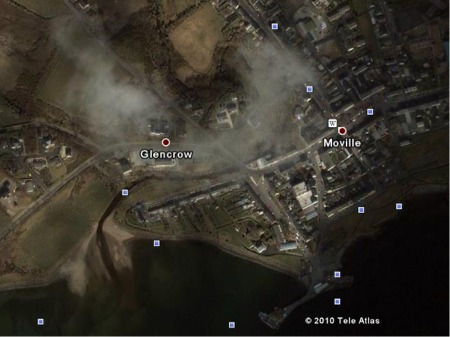
MOVILLE has become the first town in Inishowen to have clear satellite imagery included on Google Earth.
The website, which previously highlighted Derry and Muff, leaving much of Inishowen as a green and brown blur, has now extended its high definition coverage of the peninsula.
Overhead pictures taken from space now show the fields and homesteads of much of North-East Inishowen from Redcastle, Gleneely and Culdaff to Carrowmena and Moville.
New Google images also span the coastline from Caratra and Tremone across to Kinnego Bay. A cyber-traveller can zoom from Lecamy to Ballynally in a matter of seconds.
Satellite photos have captured houses and streets in Moville from the River Row to Montgomery Terrace and the Market Square. You can now check out your neighbour’s backyard from Mill Glen to Manor Court or trace the shore path from space!
The satellite high-resolution images cease at Drumaweir leaving Greencastle and Shroove under a hazy cloud. Carndonagh and Buncrana also remain in a low-definition foggy blur.
Google Earth is currently working on its plan to upload satellite images for the entire peninsula.
Return to > Top Stories    > News    > Home